


In recent years, the concept of the digital twin has gone from being an emerging trend to becoming a key tool for decision-making about the territory. These digital replicas facilitate simulation and analysis based on data, either acquired by sensors or integrated from multiple conveniently cleaned sources.
At Cinfo, always attentive to new technological opportunities with real-world impact, we have been actively involved in several projects related to this technology.
One of the most significant is the technical assistance project for digital twins, which we are developing together with SILO for AMTEGA, leveraging the Smart Territory platform of the Xunta de Galicia. The goal is to apply the potential of digital twins to different strategic sectors across the Galician territory.
What are sectoral digital twins?
A digital twin is a virtual representation of a physical system, powered by real and up-to-date data, that makes it possible to analyze, simulate, and optimize its behavior. When this approach is applied to a specific domain—such as industry, rural areas, infrastructure, or the environment—we refer to sectoral digital twins.
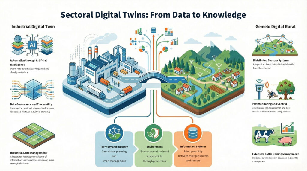
Sectoral digital twins: from data to knowledge
The project focuses on the development of sectoral digital twins—specialized digital models that integrate information from multiple sources (territorial data, sensor data, GIS layers, administrative information, etc.) to address specific needs across different domains.
This approach enables a shift from simple data storage to the generation of actionable knowledge, facilitating interoperability, data governance, and the scalability of solutions.
Industrial digital twin: data structuring and governance
The industrial digital twin is aimed at managing industrial activity and industrial land, integrating multiple heterogeneous layers of information.
At Cinfo, we have developed a tool that automates the metadata generation of the different digital twin layers using artificial intelligence techniques. This process delivers key improvements such as:
- Automatic normalization, organization, and classification of information
- Improved data quality and traceability
- Easier data governance and information reuse
- More efficient and understandable use of available data
Thanks to this intelligence layer, the digital twin becomes a robust foundation for industrial planning, scenario evaluation, and strategic decision-making.
Rural territory digital twin: sensing and sustainability
The rural territory digital twin is focused on the sustainable use of rural environments, integrating territorial information with data collected through distributed sensing technologies.
Following needs analysis visits to the villages of Trascastro and Moreda, several use cases and the associated sensing infrastructure were defined, including:
- Monitoring and control of chestnut tree pests
- Detection and tracking of the Asian hornet (Vespa velutina)
- Management of extensive cattle and pig farming
Incorporating these data into the digital twin provides an integrated and up-to-date view of the territory, supporting prevention, resource optimization, and informed decision-making.
Technology with real impact
This project demonstrates how sectoral digital twins, supported by smart territory platforms, can become a key digital infrastructure for:
- Intelligent territory management
- Data-driven industrial planning
- Environmental and rural sustainability
- Interoperability between systems and information sources
- Data-driven decision-making
At Cinfo, we continue to invest in applied and practical innovation, developing technological solutions that combine technical rigor, a pragmatic approach, and scalability. These solutions are aligned with the real needs of public administrations, the productive ecosystem, and the territory, contributing to territorial digitalization and better decision-making.